Problem planning classic flights

The "Queen of the Skies"
ApacheHunter
Airman
Posts: 46
Joined: 01 Jun 2012, 06:36

Problem planning classic flights

Post by ApacheHunter »

I have a problem regarding the planning of classic flights flying VOR to VOR along lower airspace airways. Take the leg I'm planning for a particular flight I want to maken pictured below (disregard the Spd and ETE):

Image

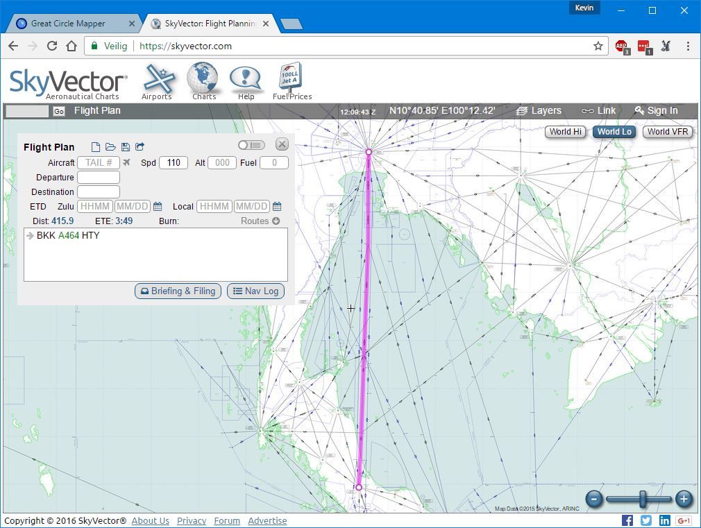
This leg is along airway A464, connecting the BKK and HTY VORs. The distance is 416 nm. However, the reception range of the VORs on either side of the airway is 130 nm. How are you supposed to fly this part of the route, as somewhere around the middle of this leg reception of both VORs will be lost? Of course I could choose another route with connecting VORs that are close to each other, but this is after all a real non-RNAV airway.

I hope somebody can help me understand this!

alan CXA651
Senior Master Sergeant
Posts: 2439
Joined: 15 Mar 2016, 08:23

Re: Problem planning classic flights

Post by alan CXA651 »

Hi.
In the real world , they would use astral/sun and dead reconing when out of ndb/vor ranges , i use skyvector for my route planning , and you may or may not be aware of the wind barbs that can be placed on the map , this gives wind speed direction on the day , also your navigator tells you the wind direction as to the direction its comming from blue arrow and speed of it , you can see from that which way you will be blown of course , so turn aircraft slightly into wind to nullify this action , in order to stay on track.
regards alan. 8)
Image
Image
Image
Image

User avatar
Jacques
Senior Master Sergeant
Posts: 2376
Joined: 26 Jun 2011, 17:54
Location: West Coast, USA

Problem planning classic flights

Post by Jacques »

Hi Apachehunter,

It is a pretty simple process. If you look at your origin VOR on A464 there will be a compass direction superimposed on your track just outside of the VOR compass rose. In this case 003°. Then move up to BKK and look where A464 enters that VOR, or nearby, and it appears to be 182°. So fly 003 until you lose contact with HTY, then fly 002° ( the reciprocal of the BKK VOR indicated on the chart...or 182-180 =002) until you begin recieving that VOR, then just correct your course to fly towards it.

Of you have Plan G, it has a very useful distance/bearing tool which suits this purpose fine.

It also helps to know what kind of VOR you are flying from/to since they can broadcast to very different distances. If you know what type it is, then you know roughly when to start picking up its signal.

mgchristy
Airman Basic
Posts: 9
Joined: 30 Jul 2010, 09:12

Re: Problem planning classic flights

Post by mgchristy »

ApacheHunter,
Alan and Jacques said it best. I fired up FSX to check, and both the BKK and HTY VORs are listed in FSX as being 'high altitude' VORs with a hard-coded reception range of 195nm - not 130nm - so if you follow an outbound radial from BKK until you lose reception, there should only be a period of about 25nm when you're out of range before you're able to pick up reception from the inbound radial of the HTY VOR. Good luck!

ApacheHunter
Airman
Posts: 46
Joined: 01 Jun 2012, 06:36

Re: Problem planning classic flights

Post by ApacheHunter »

Thanks for your answers!

So if I understand correctly: flying outside of VOR range, that is where the navigator comes in? I know in default FSX the range for this VOR is 195 nm, but I updated the navaids using the website below and this resets the range to a more realistic 130 nm. I tried the flight this afternoon and indeed I stopped receiving VOR signals when I was 130 nm out of BKK. For now, I used the KLN90B to fly this gap between BKK and HTY.

http://www.aero.sors.fr/navaids3.html

User avatar
mallcott
Staff Sergeant
Posts: 455
Joined: 13 Nov 2016, 12:19
Location: UK

Re: Problem planning classic flights

Post by mallcott »

ApacheHunter wrote:Thanks for your answers!

So if I understand correctly: flying outside of VOR range, that is where the navigator comes in? I know in default FSX the range for this VOR is 195 nm, but I updated the navaids using the website below and this resets the range to a more realistic 130 nm. I tried the flight this afternoon and indeed I stopped receiving VOR signals when I was 130 nm out of BKK. For now, I used the KLN90B to fly this gap between BKK and HTY.

http://www.aero.sors.fr/navaids3.html
Correct. You can, as navigator, also use the basic principles of IFR - `I Follow Roads`.
It's a close approximation of the `old days` `I Follow Railways`... :wink:

In the example you give it's much simpler - follow the coast.

ApacheHunter
Airman
Posts: 46
Joined: 01 Jun 2012, 06:36

Re: Problem planning classic flights

Post by ApacheHunter »

I could do that, of course, but according to the CalClassic propliner tutorial that is not how these aircraft were flown back in the days. And besides, following landscape features on longer flights gets pretty interesting in overcast and/or reduced visibility conditions.

User avatar
mallcott
Staff Sergeant
Posts: 455
Joined: 13 Nov 2016, 12:19
Location: UK

Re: Problem planning classic flights

Post by mallcott »

ApacheHunter wrote:I could do that, of course, but according to the CalClassic propliner tutorial that is not how these aircraft were flown back in the days. And besides, following landscape features on longer flights gets pretty interesting in overcast and/or reduced visibility conditions.
Then you need to get familiar with stopwatch and compass, relative bearings and wind-adjusted headings.
Having long periods with NO radio Nav was how it was flown back in the day.

And you aren't really flying in a classic manner unless you turn off all but the ADF navaids - that's closer to what they had then. VOR's were introduced from about 1946 for key areas, but didn't become universal in the States until the mid-Sixties and the arrival of solid-state electronics - well after the early version Connie's time.

Can make dead reckoning very interesting. :lol:

ApacheHunter
Airman
Posts: 46
Joined: 01 Jun 2012, 06:36

Re: Problem planning classic flights

Post by ApacheHunter »

Thanks for the information! I must have understood something wrongly then. The tutorial clearly states that 'the trick when simulating 1932-55 is to ensure that the flight plan is based solely on VORs, intersections, and not at all on NDBs or DME fixes.' However, I didn't read these lines: 'We will only use a fix defined by DME when simulating 1955 to the present day and only when flying over ‘advanced nations’ with classic era infrastructure prior to 1970. Over ‘undeveloped’ nations we will use only pioneer and vintage phase navigation techniques right through to 1970.' So, I guess this part of the world didn't have VORs back in those days and indeed I should navigate using pioneer and vintage era techniques.

On oceanic flights, did they use celestial navigation and the weatherships?

alan CXA651
Senior Master Sergeant
Posts: 2439
Joined: 15 Mar 2016, 08:23

Re: Problem planning classic flights

Post by alan CXA651 »

Hi.
Oceanic flights used sextants , stars by night sun by day , coupled with dead reconing , good weather info as to wind speeds and direction to correct for drift , and when weather permitted looking for islands , and landclass to veryify their position , and there is always room for error under these conditions , so if they where off by 5 to 10 nm in places they could correct this if they saw any land mass to confirm their position.
regards alan. 8)
Image
Image
Image
Image

User avatar
rosariomanzo
Staff Sergeant
Posts: 308
Joined: 26 Sep 2009, 06:48
Location: LIRN

Re: Problem planning classic flights

Post by rosariomanzo »

During the last flights with the same issues (blind zones between ndbs) i had a lot of fun using an e6b calculator. There are many smartphone apps around for this. Tracking a radial outbound, when you loose the signal, you can use the navigator information and get the heading to keep taking into account wind, oat and pressure altitude. It is a nice feeling to be on track when next ndb comes alive.

Inviato dal mio SM-J500FN utilizzando Tapatalk
Ros

User avatar
ratty
Technical Sergeant
Posts: 902
Joined: 29 Oct 2013, 21:08
Location: KPMP

Re: Problem planning classic flights

Post by ratty »

alan CXA651 wrote:Hi.
Oceanic flights used sextants , stars by night sun by day , coupled with dead reconing , good weather info as to wind speeds and direction to correct for drift , and when weather permitted looking for islands , and landclass to veryify their position , and there is always room for error under these conditions , so if they where off by 5 to 10 nm in places they could correct this if they saw any land mass to confirm their position.
regards alan. 8)
Exactly! And their cojones were larger, too. (Is it OK to say that?)
Image

Stratocruiser2
Senior Airman
Posts: 160
Joined: 14 Feb 2016, 06:35
Location: Wales

Re: Problem planning classic flights

Post by Stratocruiser2 »

rosariomanzo wrote:During the last flights with the same issues (blind zones between ndbs) i had a lot of fun using an e6b calculator. There are many smartphone apps around for this. Tracking a radial outbound, when you loose the signal, you can use the navigator information and get the heading to keep taking into account wind, oat and pressure altitude. It is a nice feeling to be on track when next ndb comes alive.

Inviato dal mio SM-J500FN utilizzando Tapatalk
It is very satisfying to use an e6b and then eventually pick up an NDB signal confirming your track is good. Another nice little add-on for simulating transatlantic navigation of the era is the freeware weathership gauge, which simulates the NDB signals generated by weather ships stationed at various positions in the Atlantic which can then be tracked by a rotatable ADF. There is a thread on this weathership gauge here on the Connie forum if you haven't already found it.

Bill

User avatar
rosariomanzo
Staff Sergeant
Posts: 308
Joined: 26 Sep 2009, 06:48
Location: LIRN

Re: Problem planning classic flights

Post by rosariomanzo »

Stratocruiser2 wrote: It is very satisfying to use an e6b and then eventually pick up an NDB signal confirming your track is good. Another nice little add-on for simulating transatlantic navigation of the era is the freeware weathership gauge, which simulates the NDB signals generated by weather ships stationed at various positions in the Atlantic which can then be tracked by a rotatable ADF. There is a thread on this weathership gauge here on the Connie forum if you haven't already found it.
Bill
Yes I know about the weathership gauge, thanks! :wink:
Ros

ApacheHunter
Airman
Posts: 46
Joined: 01 Jun 2012, 06:36

Re: Problem planning classic flights

Post by ApacheHunter »

I actually picked up a used metal E6B, but I'm not completely familiar with it yet; something to study in the future. Thanks for the suggestion!

To be honest: it can at times feel a little weird to be unable to know your exact position in this GPS era. You have to try to change your complete mindset to how things worked more than 50 years ago.

Verstuurd vanaf mijn LG-H815 met Tapatalk

new reply

Return to “Lockheed Model 049 Constellation”

Who is online

Users browsing this forum: No registered users and 33 guests