Page 1 of 1
Where is my GPS!? how do I navigate?
Posted: 07 Apr 2015, 10:56
by sidfadc
Bought this last night, what a wonderful aircraft! On a 75 year old aircraft I knew GPS would be off the table. I was expecting something though! From what I can see I have the heading indicator which is great for knowing which direction I'm pointing. But how do I navigate from point to point? I can press Shift-6 to bring up a COM radio but with no instruments seemingly (VOR?) how do I actually get from A to B.
Is someone going to sarcastically tell me in WW2 it was all done with the naked eye?

Cheers
Sid
Re: Where is my GPS!? how do I navigate?
Posted: 07 Apr 2015, 11:03
by FlipS
Try Shift + 5
During the war most was done with radar and radio. It was not wise to navigate over enemy territory on beacons.
Re: Where is my GPS!? how do I navigate?
Posted: 07 Apr 2015, 11:17
by sidfadc
Thanks! I know about the shift-5 map, I also use Plan G so that will come in handy as well. I guess there is absolutely no point in importing a flight plan then? Is it just a case of getting airborne and flying in a general direction until the airport is visible?
Re: Where is my GPS!? how do I navigate?
Posted: 07 Apr 2015, 11:39
by Molly - A2A
If you load a flight plan the shift-5 map will show it.
Re: Where is my GPS!? how do I navigate?
Posted: 07 Apr 2015, 11:57
by sidfadc
But I assume there is no way to know I am on track to a VOR using instrument display? It all has to be done with the real time map (or Plan G)?
Re: Where is my GPS!? how do I navigate?
Posted: 07 Apr 2015, 12:05
by robert41
Pilotage and dead reckoning.
Re: Where is my GPS!? how do I navigate?
Posted: 07 Apr 2015, 17:07
by Nick - A2A
Hey Sid,
This website provides a rather good overview of navigation as it applies to flight sim, including dead reckoning...
http://www.navfltsm.addr.com/basic-nav-general.htm
...And here are a couple of period instructional videos which may be worth a glance (or a listen for the stirring music alone

):
[youtube]
http://www.youtube.com/watch?v=BEatUIZzO_o[/youtube]
[youtube]
http://www.youtube.com/watch?v=NQWZEVaoFKQ[/youtube]
Finally, a rather chilling reminder of what can happen if you get it wrong...
http://en.wikipedia.org/wiki/Flight_19
All the best,
Nick
Re: Where is my GPS!? how do I navigate?
Posted: 07 Apr 2015, 17:59
by Skycat
You can add the default FSX GPS unit from the Microsoft Cessna 172 to the unassigned panel slot, so it will come up when you use "Shift+1."
Here's how you would do that for the B-17G; you'll have to use the Spitfire folder and .CFG of course:
Go to to FSX --> SimObjects --> Airplanes --> WoP_b17g. Open the "Panel" subfolder and find the Panel.cfg document. Make a backup copy of this document and then open the original in Notepad or similar editor. Scroll down to the [Window00] section of the original document and change that whole block (including the "guage=tester!tester," line) to:
[Window00]
size_mm=456,378
window_size=0.5
position=8
BACKGROUND_COLOR=0,0,0
VISIBLE=0
ident=10
gauge00=fs9gps!gps_500, 0,0
Save and close. Now you should be able to bring up the GPS panel with Shift+1 when you are flying the B-17G in FSX.
Re: Where is my GPS!? how do I navigate?
Posted: 08 Apr 2015, 06:14
by SpitfireMelodeon
Very interesting instructional films.
I was particularly interested in the 'RAF Low Flying Navigation' part 1 as there are aerial scenes of country very local to myself.
For anyone interested the 'small isolated hill' at 4.15 is the westernmost point of the Sinodun hills known locally as Wittenham Clumps, very close to Days Lock on the River Thames.
And at 4.55 the 'chimney of isolated works' is the cement works just to the south of Chinnor, South Oxfordshire which still existed until very recently having been pulled down about 5 years ago and now appears on satellite photographs as a chalk pit.
The featured radio masts are probably from the famous site at Hillmorton near Rugby.
For those with photographic scenery it is great to recreate this flight but of course it only works well if you are much higher, for instance around 2000 ft
Cheers and Beers
Bill
Re: Where is my GPS!? how do I navigate?
Posted: 08 Apr 2015, 10:07
by robert41
Thanks for the links Nick. Good stuff.
Re: Where is my GPS!? how do I navigate?
Posted: 15 Apr 2015, 04:07
by Nick - A2A
SpitfireMelodeon wrote:Very interesting instructional films.
I was particularly interested in the 'RAF Low Flying Navigation' part 1 as there are aerial scenes of country very local to myself.
For anyone interested the 'small isolated hill' at 4.15 is the westernmost point of the Sinodun hills known locally as Wittenham Clumps, very close to Days Lock on the River Thames.
And at 4.55 the 'chimney of isolated works' is the cement works just to the south of Chinnor, South Oxfordshire which still existed until very recently having been pulled down about 5 years ago and now appears on satellite photographs as a chalk pit.
The featured radio masts are probably from the famous site at Hillmorton near Rugby.
For those with photographic scenery it is great to recreate this flight but of course it only works well if you are much higher, for instance around 2000 ft
Cheers and Beers
Bill
Glad you found the low flying nav vids interesting Bill. After watching them I was seriously tempted to try this exercise for myself, but as you point out, photographic scenery would be rather a pre-requisite; not sure the ORBX stuff would cut it! I'm also rather certain than my flying skills wouldn't 'cut it' either as holding a course to 1° whilst checking for landmarks and so on and doing lots of mental arithmetic with regards to course correction sounds like rather a high workload. Easy to see why they had a dedicated navigator in aircraft like the Mossie.
Even with photoreal scenery, I think it would be rather hard to recreate an authentic 'period' navigation exercise. The abundance of motorways, dual-carriageways and so on would be a real benefit which was denied to the WWII pilots.
All the best,
Nick
Re: Where is my GPS!? how do I navigate?
Posted: 16 Apr 2015, 10:17
by bladerunner900
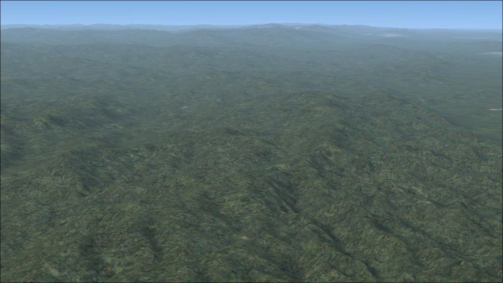
I love to fly VFR and low with Plan-G3, so Photo-real is not for me. When I got ORBX Wales, the first thing I did was to fly a 74 mile route I have been driving on for the last 25 years. I found it quite representative of the surrounding countryside. Granted the towns and buildings are a generic representation but all the rivers, junctions, roundabouts, railway/road crossings seem to be present. It even has some of the larger buildings represented. I was quite pleased to see DVLC Swansea and some local industry represented for instance. And the countryside looks even better now I have added ORBX trees. Subtle but better.
Steve.
Re: Where is my GPS!? how do I navigate?
Posted: 16 Apr 2015, 12:28
by r601020
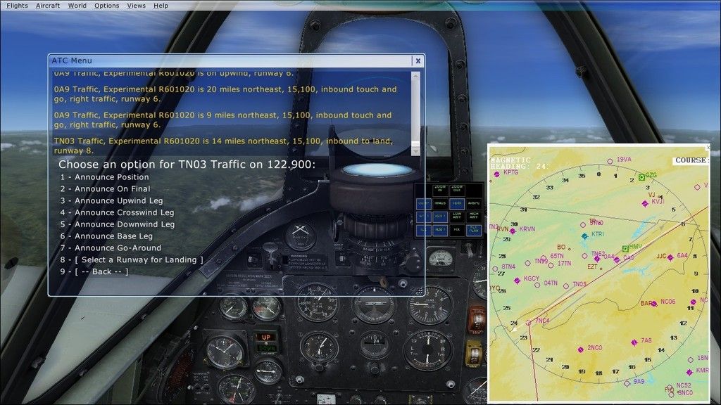
It's not perfect, but here's how I'm doing it.
Have a flight plan.
Then, ping the small airports along the way via landing intentions with "announce position" for distance. With larger airports, having a controller, use "unfamiliar with airport" for distance.
Re: Where is my GPS!? how do I navigate?
Posted: 24 Apr 2015, 00:52
by n421nj
I use pilotage and the shift map.